Elisabeth Klocke en: Unterschied zwischen den Versionen
Till (Diskussion | Beiträge) (→Elisabeth Klocke) |
Till (Diskussion | Beiträge) (→Elisabeth Klocke) |
||
| (45 dazwischenliegende Versionen desselben Benutzers werden nicht angezeigt) | |||
| Zeile 1: | Zeile 1: | ||
| − | ===Elisabeth Klocke=== | + | === Elisabeth Klocke === |
| − | BSU | + | BSU Department of Urban Development and Environment, Ministry of Hamburg.<br/>Working group Elbe Estuary (2012): The Integrated Managementplan for the Elbe Estuary, [http://www.natura2000-unterelbe.de/english.php www.natura2000-unterelbe.de] |
| − | '''Towards sustainability – The Integrated Managementplan for the Elbe Estuary ''' | + | <span style="font-size:larger">'''Towards sustainability – The Integrated Managementplan for the Elbe Estuary'''</span> |
| − | + | Evening lecture for [[Living with Rivers in Germany and in India en|"Living with Rivers in Germany and in India: Ecology, Religion and Economy at Elbe, Ganges and Yamuna"]] on 21 Oct 2011 on the barge Caesar. | |
| − | Ecology, Religion and Economy at Elbe, Ganges and | ||
| − | |||
| − | |||
| − | + | {| width="650" border="1" cellpadding="10" cellspacing="0" | |
| + | |- | ||
| + | | | ||
| + | <span style="font-size:larger"><span style="font-family: times new roman,times,serif">'''Abstract:'''</span></span> | ||
| − | + | <span style="font-size:larger"><span style="font-family: times new roman,times,serif"></span></span> | |
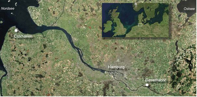
| − | + | <br/>[[File:72 630 Elbe-estuary.jpg|link=]]<span style="font-size:x-small"><span style="font-family: times new roman,times,serif"><span style="font-size:small">The Elbe Estuary Credits: Integrated Management Plan for the Elbe Estuary</span></span></span> | |
| − | + | <br/><span style="font-size:medium"><span style="font-family: times new roman,times,serif">The Elbe estuary has been subject to anthropogenic changes for several hundreds of years. Huge parts of the estuary margins have been diked for land claim and flood defence. The channel morphology within the estuary has been modified severely for navigation purposes.</span></span> | |
| − | + | <span style="font-size:medium"><span style="font-family: times new roman,times,serif">Despite these changes, the Elbe Estuary is still of outstanding ecological significance. With the exception of the Port of Hamburg and some smaller areas near Brunsbüttel, Cuxhaven and Stade, more than 90 % of its waters and floodplains, are special areas of conservation under the EU Habitats Directive. It is thus a part of the European natural heritage.</span></span> | |
| − | + | <span style="font-size:medium"><span style="font-family: times new roman,times,serif">In order to conserve the valuable habitats and species and to harmonise ecological and economical demands in the area, the three federal states of Hamburg, Lower Saxony and Schleswig-Holstein, the Hamburg Port Authority and the German Federal Administration of Waterways and Navigation set out to draw up an integrated plan for the estuary management.</span></span> | |
| + | <span style="font-size:medium"><span style="font-family: times new roman,times,serif">Legally, the integrated management plan is based on article 6 habitats directive, stipulating that member states are to establish measures necessary for creating favourable conditions for habitats and species. Beyond objectives of nature conservation, economic as well as social, infrastructural and regional were taken into account and integrated into an overall concept. Shared objective was to integrate nature conservation and development objectives both much earlier and stronger within the context, especially in the design of specific development plans or projects.</span></span> | ||
| + | <span style="font-size:medium"><span style="font-family: times new roman,times,serif">The integrated management plan is a directive for the acting state. It is meant to provide clarity and predictability for all actors without having legal binding force towards any current use.</span></span> | ||
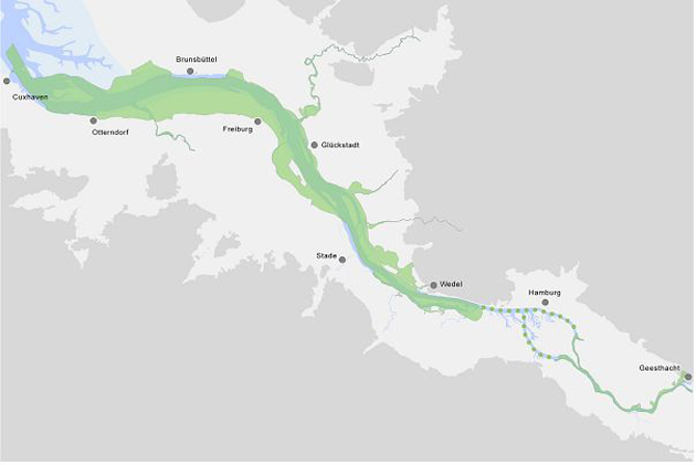
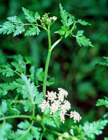
| − | [[Elisabeth | + | <span style="font-size:medium"><span style="font-family: times new roman,times,serif">The area covered by the Integrated Management Plan extends from the Geesthacht weir to the mouth of the river over a total length of approx. 135 river km, all in all an area of about 46.000 ha. Being the vitally important connection between the NATURA 2000-sites upstream and downstream of the port, the port of Hamburg was also subject to the planning. The plan defines common conservation objectives for 14 habitat types, amongst which the habitat type “estuary” is to be highlighted, and 9 species and several species of wild birds. One of the focus points of the management plan is the Elbe water dropwort, an endemic plant, which is threatened with extinction.</span></span> |
| + | |||
| + | [[File:72 630 Planungsraum.jpg|link=]]<br/><span style="font-size:small"><span style="font-family: times new roman,times,serif">Area covered by the integrated management plan Credits: integrated management plan for the Elbe estuary</span></span> | ||
| + | |||
| + | <br/><span style="font-size:medium"><span style="font-family: times new roman,times,serif">The strong anthropogenic change of the tidal dynamics, especially the tidal range, and the oxygen deficiency situations in summer are of particular importance for the management scheme. The presentation will explain the management scheme for the Elbe water dropwort in greater detail. It will be shown that diversity of species can only be ensured by a joint management of all partners.</span></span> | ||
| + | |||
| + | [[File:72_450_b_Oenanthe-conioides-©KlausJanke-003.jpg|link=]]<br/><span style="font-size:small"><span style="font-family: times new roman,times,serif">Elbe water dropwort, ''Oenanthe conioides'' © Klaus Janke</span></span> | ||
| + | |||
| + | |||
| + | |||
| + | |} | ||
| + | |||
| + | |||
| + | |||
| + | [[Elisabeth Klocke en#top seitenanfang|Top]] | ||
Aktuelle Version vom 25. März 2012, 19:39 Uhr
Elisabeth Klocke
BSU Department of Urban Development and Environment, Ministry of Hamburg.
Working group Elbe Estuary (2012): The Integrated Managementplan for the Elbe Estuary, www.natura2000-unterelbe.de
Towards sustainability – The Integrated Managementplan for the Elbe Estuary
Evening lecture for "Living with Rivers in Germany and in India: Ecology, Religion and Economy at Elbe, Ganges and Yamuna" on 21 Oct 2011 on the barge Caesar.
|
Abstract:
Despite these changes, the Elbe Estuary is still of outstanding ecological significance. With the exception of the Port of Hamburg and some smaller areas near Brunsbüttel, Cuxhaven and Stade, more than 90 % of its waters and floodplains, are special areas of conservation under the EU Habitats Directive. It is thus a part of the European natural heritage. In order to conserve the valuable habitats and species and to harmonise ecological and economical demands in the area, the three federal states of Hamburg, Lower Saxony and Schleswig-Holstein, the Hamburg Port Authority and the German Federal Administration of Waterways and Navigation set out to draw up an integrated plan for the estuary management. Legally, the integrated management plan is based on article 6 habitats directive, stipulating that member states are to establish measures necessary for creating favourable conditions for habitats and species. Beyond objectives of nature conservation, economic as well as social, infrastructural and regional were taken into account and integrated into an overall concept. Shared objective was to integrate nature conservation and development objectives both much earlier and stronger within the context, especially in the design of specific development plans or projects. The integrated management plan is a directive for the acting state. It is meant to provide clarity and predictability for all actors without having legal binding force towards any current use. The area covered by the Integrated Management Plan extends from the Geesthacht weir to the mouth of the river over a total length of approx. 135 river km, all in all an area of about 46.000 ha. Being the vitally important connection between the NATURA 2000-sites upstream and downstream of the port, the port of Hamburg was also subject to the planning. The plan defines common conservation objectives for 14 habitat types, amongst which the habitat type “estuary” is to be highlighted, and 9 species and several species of wild birds. One of the focus points of the management plan is the Elbe water dropwort, an endemic plant, which is threatened with extinction.
|